SUNSHINE
Delivered smart services for energy-efficient urban management. Developed tools for building energy assessment, public lighting optimization, and heating control using weather forecasts and GIS data, with pilots across European cities.

Delivered smart services for energy-efficient urban management. Developed tools for building energy assessment, public lighting optimization, and heating control using weather forecasts and GIS data, with pilots across European cities.
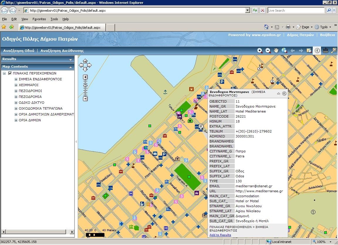
Developed and deployed the Spatial Data Infrastructure (SDI) for the Patras region, aligning with INSPIRE and OGC standards. Delivered GIS tools, public web services (WMS/WFS), stakeholder training, awareness booths, and long-term capacity building for urban planning and land administration.
SPATIAL DATA PATRA Read More »

Implemented Malta’s Shared Environmental Information System aligned with INSPIRE and EEA protocols. Developed SDI infrastructure, Geoportal tools, and interoperable databases for air, water, land, and noise data.
Delivered accredited GIS and geomatics training to public servants in Malta. Developed L4 and L5 programmes, hands-on courses, and technology-enhanced learning tools aligned with national workforce needs.

Promoted integration of water, energy, and food systems for a circular, low-carbon economy. Engaged 48 partners across Europe in policy harmonization, training, and best practice sharing through a multi-sectoral Nexus framework.

Developed a VR-based small boat simulator for skipper training. Delivered immersive environments, real-time weather simulations, cloud computing platform, and instructor tools for improving maritime safety through experiential learning.
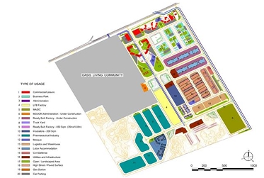
Designed wet utility networks for Jeddah Oasis including potable water, sewerage, irrigation, stormwater, and flood protection systems. Complied with MODON and KSA specifications, covering full schematic to construction design.

Designed Greece’s National Geology GIS System with 40 thematic layers across 30 regions. Produced digital and print geological products, reinforced IGME’s research capabilities, and developed a commercial data distribution platform.
Developed an emergency management system for oil spill monitoring using satellite remote sensing and GIS. Included image analysis, simulation models, database tools, and decision support for public authorities across the Mediterranean.
Conducted EIA for the “Panagia–Makryxwri” section of the E65 motorway through sensitive NATURA 2000 areas. Addressed biodiversity, land use, population distribution, and non-point source pollution in Pindos and Kalabaka regions.