GEOSMART CITY
GeoSmartCity contributes to the Smart City implementation by establishing a cross-platform, re-usable and open hub able to publish open geographic information and to provide specialized services based on open standards.

GeoSmartCity contributes to the Smart City implementation by establishing a cross-platform, re-usable and open hub able to publish open geographic information and to provide specialized services based on open standards.

The purpose of the project is to evaluate the risk from known threats and hazards that have the potential to significantly impact Malta’s security.

Open 3D-platform for three smart city services: routing,, renewable energy, real-time noise mapping, interfaced into the City Operations via webservices.
Hub for indoor open geomatics data regarding public spaces and hospitals, integrating middleware for indoor/outdoor tracking and management of people and assets.

Supporting Action to turn the challenges of the INSPIRE implementation into business opportunities for the Geo-ICT European SMEs, with an EU-wide completion.

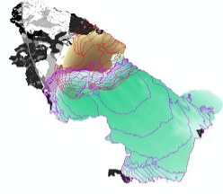
Geomatics / GIS methodology for Soil Fuel Classification production and mapping (FCM Webservices) based on INSPIRE principles, supporting the ArcFIRE wildfires platform

NEXUS modeling platform addressing complexities of interconnection between Land, Food, Energy, Water and Climate via thematic simulation themes and Dashboard tech.
Integrated wild-fire forestry emergency management / monitoring system for the Sex-Sou Forest, N. Greece, based on 16 pilar sensors/cameras, image recognition etc. tech.
ArcGIS technology to produce three-dimensional Aerodrome Navigational Databases for the General Aviation, and a database with 2000+ 3D-visualized EU aerodromes
Remote sensing (ESA/Copernicus) technology delivering sustainable solutions to overcome broomrape plant parasitism in Mediterranean agricultural systems.