DIGITAL-SEE
DIGITAL-SEE aims at sharing spatial digital information across South East Europe, in three phases feasibility, technology implementation and pilots commercial operation.
DIGITAL-SEE aims at sharing spatial digital information across South East Europe, in three phases feasibility, technology implementation and pilots commercial operation.
The project creates a fully integrated water system which ties together all parts of the network, including the geographic information system (GIS), water leakage management system, pumping station control systems and the SCADA systems at each service branch. EPSILON is supplying a 5-years training and a 3-year preventative maintenance.
The project aimed at an integrated river management dealing with hydrologic and environmental engineering studies related to the storm drainage of the National Railway of Greece.
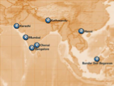
The ASIA_CITY project supplies a platform for the local-regional tourism authorities in Asia aimed to develop-enhance their tourism plans by pre-senting a commonly accepted plan -a Joint Strategy- in the IST technology field of “on-line navigational city information”.
The project aimed to develop a theory and a mathematical model platform combined with a tool to assist decision makers to estimate sustainability of regions and generate and cluster environmental sustainability indicators (ESIs) for EU-NUTS-II and NUTS-III regions.
ENVIRONMENTAL POLICY VIA SUSTAINABLITY INDICATORS AT EUROPEAN-WIDE NUTS Read More »

Based on cost-sharing development contracts signed with both, the European Commission and Government of Greece, EPSILON has produced the statistical database for the country, which has been linked to the NUTS-X geographic system of the country and the Eurostat development sectors of a country.
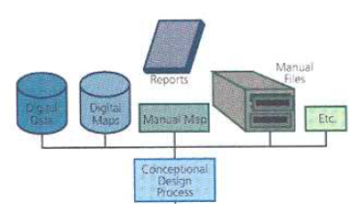
“National Register of Roads”, is defined as the integrated database of geographical and descriptive data that supports the rational structuring and organizing the management of road network data in the country and will create the platform of an Integrated Geographic Information System for managing road network and road environment in the country.
National Register of Roads Read More »
The NPS research project establishes a network of Mediterranean & Black Sea scientific organizations on state-of the-art GIS technologies as remote sensing and mathematical modelling integrated in a GIS database for the control and surveillance of Mediterranean & Black sea coastal water resources and the estimation of NPS pollution impacts.

COPESTAT (Copernicus Countries Statistical Services) plans, streamlines, and selective applies a statistical database to Copernicus-Networks, capable to providing and marketing statistical information (east-west, west-east) via information technology infrastructure, electronic media, telematics and GIS.
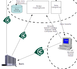
EGIS (Pan-European Environmental GIS) presents an approach to handling environmental GIS information with mapping and networking as an effective concerted planning tool for sustainability and environmental protection.