SIntegraM
Creation of a cohesive spatial data infrastructure (SDI) for all Maltese entities, ensuring standardized interoperability of 70+ interconnected Geomatics systems
Creation of a cohesive spatial data infrastructure (SDI) for all Maltese entities, ensuring standardized interoperability of 70+ interconnected Geomatics systems
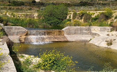
GIS database for 71 Dams and 75 Reservoir sites, to accommodate dams/reservoirs technology inspection, water – agricultural usage, rehabilitation regulatory policy
Technology support services to the MITA (Malta Information Technology Agency) related to the implementation of the EC INSPIRE directive, across multiple sectors
New Generation of a recoverable low-cost micro-UAV platform for wildfires, structurally robust to fly through the fire and acquire/forward real-time info for fire management
Multi-Risk platform based on risk models for 9 hazards: earthquake, wildfire, landslide, ground movement, volcano, tsunami, extreme weather, flood, industrial accident.
Copernicus is the European Union’s Earth revolutionary Earth Observation and Monitoring program, which is monitoring our planet and its environment by a set of satellites and taking a continuous “health check” of the Earth.
Earth observation technology (Sentinel-4/5) to monitor the atmospheric ozone profile with unprecedented accuracy with multiple applications, incl. UV skin-heath impacts