NEUROCLIMA
Developed a neurocomputing-powered framework to enhance climate modelling and adaptation strategies. Delivered co-creation tools, digital dialogues, and AI modules to support the EU Adaptation Strategy and climate literacy.

Developed a neurocomputing-powered framework to enhance climate modelling and adaptation strategies. Delivered co-creation tools, digital dialogues, and AI modules to support the EU Adaptation Strategy and climate literacy.

Smart city digital twin ecosystem for disaster resilience. Integrated Copernicus, UAVs, and AI for early warning, real-time risk monitoring, and emergency simulation with cross-border collaboration features.

The objectives of this project are to improve the assessment and management of urban risks in the 25 members of the European Union and to arrive at recommendations for a European wide urban risk assessment, and management strategies to ensure better prevention, preparedness and response in the context of an integrated Civil Protection System.
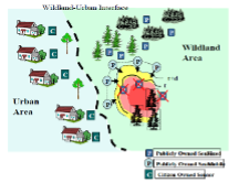
SCIER is implementing a multi-risk management platform, characterized by an open architecture based on EU standards, which incorporates different models that share common data inputs and deliver standardized outputs that can be visualized and analysed via a GIS user-friendly environment.
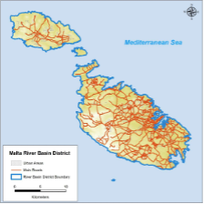
The overall objective of the contract is the preliminary assessment of the Malta River Basin District for the identification of catchments with a potential significant flood risk, including the development of a national scale predictive model.
FLOOD RISK AT THE CATCHMENT SCALE Read More »
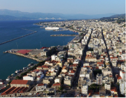
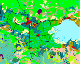
The project delivers the SDI for the region of Patras and builds GIS enabled s/w applications that support local/regional Stakeholders in their day-to-day activities.
Design and Implementation of an Integrated Geodatabase for the Municipality of Patra Read More »
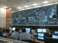
This multi-million project was initiated in 2003 and aimed at the covering of the security of the entire sector of the Olympics Games ATHENS2004. It involved real time security monitoring and actions for athletes, population, VIPS, city security, administration security, visitor’s security, international organizations security and numerous other sectors
Olympic Games 2004 C4I Read More »

It aims at delivering time-aware extension of data models developed in the context of previous/ongoing EU INSPIRE related projects, application based on the integration of existing databases and services and value added services for spatio-temporal data management, processing, analysis and interactive visualization.
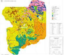
The overall objective of the project was the design and development of a Geographic Information System for the prevention and monitoring of natural disasters that derived from forest fires at the university forest Taxiarchis – Vrastamon as well as a zone of one kilometre around the forest.
The NPS research project establishes a network of Mediterranean & Black Sea scientific organizations on state-of the-art GIS technologies as remote sensing and mathematical modelling integrated in a GIS database for the control and surveillance of Mediterranean & Black sea coastal water resources and the estimation of NPS pollution impacts.