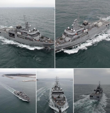
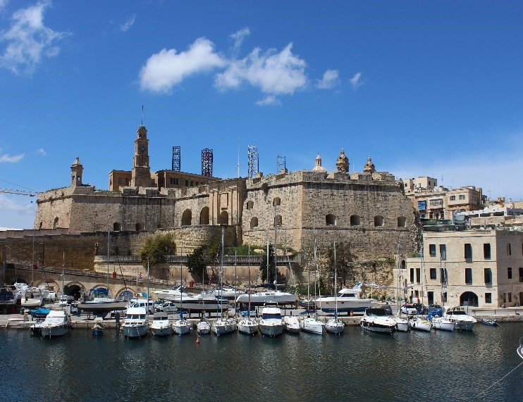
Epsilon Malta Ltd assists the AFM Project Team to prepare the tender documentation for the procurement of the new offshore patrol vessel.
Developed UAV and satellite-based tools to manage herbicide-resistant weeds in rice farming. EPSILON delivered GIS mapping, cloud platform integration, and predictive risk algorithms.
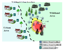
A modular and scalable GIS-based platform designed to support the entire life-cycle of forest and wildland fire management. It delivers situational awareness, early warning, crisis simulation, post-disaster impact assessment, and knowledge dissemination tools for Civil Protection and Disaster Risk Management (DRM) authorities. Brochure

Geomatics / GIS methodology for Soil Fuel Classification production and mapping (FCM Webservices) based on INSPIRE principles, supporting the ArcFIRE wildfires platform
Proposed to develop and demonstrate an autonomous passenger ferry system for coastal commuting, integrating advanced sensors, infrastructure connectivity, cybersecurity, and real-time monitoring. Included feasibility studies, pilot operations in Germany and Greece, and long-term handover to the Hellenic Navy.
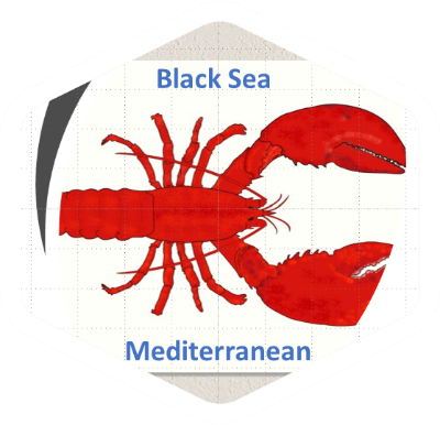
The NPS research project establishes a network of Mediterranean & Black Sea scientific organizations on state-of the-art GIS technologies as remote sensing and mathematical modelling integrated in a GIS database for the control and surveillance of Mediterranean & Black sea coastal water resources and the estimation of NPS pollution impacts.
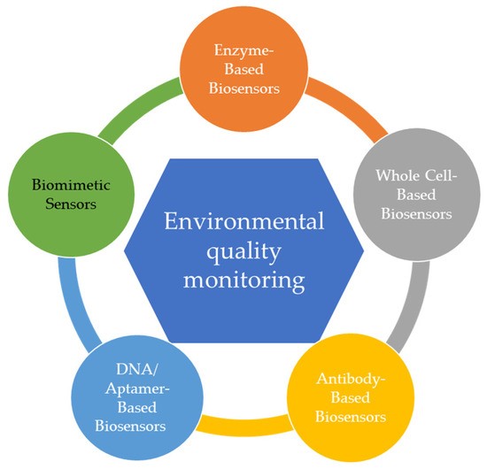
Proposed to design modular biosensors for detecting pollutants in water using advanced materials, RNA-based elements, and fiber-optic or microelectronic systems. Targeted TRL5 with in situ validation, LCA analysis, and integration with EU environmental data platforms under Zero Pollution Action Plan goals.
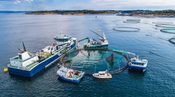
Management technologies and training for the reduction of marine debris from the fisheries and aquaculture value chain in 6 European Mediterranean ecosystems.

It aims at delivering time-aware extension of data models developed in the context of previous/ongoing EU INSPIRE related projects, application based on the integration of existing databases and services and value added services for spatio-temporal data management, processing, analysis and interactive visualization.
Evaluation of the sustainable exploitation of fish waste for the extraction of bioactive molecules (BAMs) and marine collagen for applications in health, cosmetics, nutraceuticals, and agri-food industries. EPSILON led the socio-economic and environmental impact assessments under WP6 of the project.

CITY-WELLNESS proposed the development of a globally scalable, AI-powered Software-as-a-Service (SaaS) platform to support urban decision-makers in implementing zero-pollution strategies. Building upon Horizon 2020 NetZeroCities and EO4EU technologies, the platform integrates environmental monitoring, health risk assessment, and socio-economic indicators into a City Digital Twin (CDT) and a City-Wellness Index (CIWI).
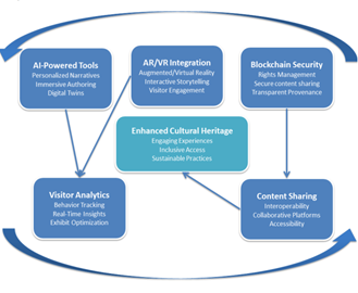
CLIO-Cloud proposed to enhance digital cultural heritage practices across Europe by developing a suite of advanced AI-powered authoring tools, integrated within the European Collaborative Cloud for Cultural Heritage (ECCCH). The project leveraged extended reality (AR/VR), artificial intelligence, blockchain, and real-time visitor analytics to foster immersive, personalized, and sustainable interactions with cultural heritage assets.
Designed a cyber-secured decision support toolbox to enhance maritime surveillance capabilities. Developed scenario simulators, multi-layer GIS modules, risk assessment tools, and a foresight technology watch platform.
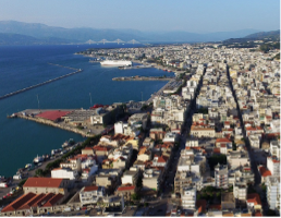
The project delivers the SDI for the region of Patras and builds GIS enabled s/w applications that support local/regional Stakeholders in their day-to-day activities.
Established an Environmental Economics and Policy Centre in St. Petersburg through EU–Russia academic cooperation. EPSILON led training, curriculum design, EU law transfer, and creation of long-term institutional ties.

Proposed to create an intelligent logistics platform using Digital Twins, AI, and blockchain to optimize multimodal supply chains. Targeted zero-emission logistics and synchronized transport operations through real-time simulation and stakeholder integration across European corridors.
An integrated GIS and remote sensing platform for flood risk monitoring across the Mediterranean and Black Sea basins. Provided modeling tools, land use mapping, water quality parameterization, and training workshops in 6 countries.
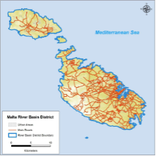
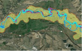
The overall objective of the contract is the preliminary assessment of the Malta River Basin District for the identification of catchments with a potential significant flood risk, including the development of a national scale predictive model.
Proposed to support border surveillance using Copernicus SAR data to detect high-speed “go-fast” smuggling boats. Combined Sentinel-1 data analysis, ship wake detection, and AIS fusion for activity pattern analysis in Mediterranean sea corridors.

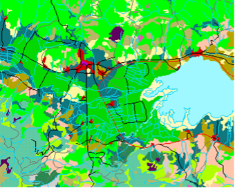
Designed Greece’s National Geology GIS System with 40 thematic layers across 30 regions. Produced digital and print geological products, reinforced IGME’s research capabilities, and developed a commercial data distribution platform.
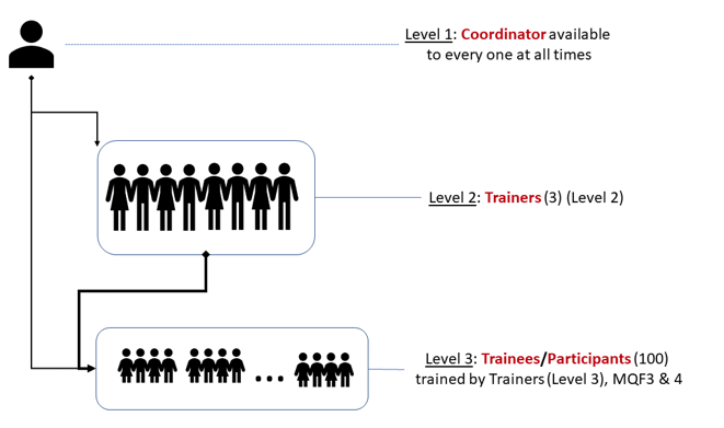
Proposed to train 140 public servants in Malta on GIS and remote sensing. Delivered modular courses (basic and advanced), skill assessments, and digital resources to improve spatial planning capacity and compliance with EU data directives (e.g. INSPIRE, Aarhus).
Multi-Risk platform based on risk models for 9 hazards: earthquake, wildfire, landslide, ground movement, volcano, tsunami, extreme weather, flood, industrial accident.

Proposed to deliver a modular geo-referenced cloud platform (HPlus) for climate risk analysis, remediation, and lifecycle-based decision-making on cultural heritage sites. Included visualization tools, pilot sites, conservation guidelines, and an EEIG for long-term platform operation.
Proposed to deliver a modular geo-referenced cloud platform (HPlus) for climate risk analysis, remediation, and lifecycle-based decision-making on cultural heritage sites. Included visualization tools, pilot sites, conservation guidelines, and an EEIG for long-term platform operation.

Developed a VR-based small boat simulator for skipper training. Delivered immersive environments, real-time weather simulations, cloud computing platform, and instructor tools for improving maritime safety through experiential learning.
Open 3D-platform for three smart city services: routing,, renewable energy, real-time noise mapping, interfaced into the City Operations via webservices.

Developed a metagenomics-based platform for detecting allergens and verifying food authenticity in high-value products. Integrated blockchain for secure traceability and supported businesses in on-site sampling and food fraud prevention.
The project involved the design, development, deployment, and maintenance of an interactive web-based educational platform for the Gharb Local Council, Gozo, under the Interreg V-A Italia-Malta AMPPA project. The goal was to enhance public awareness on marine biodiversity, sustainability, and environmental conservation through gamified digital tools.
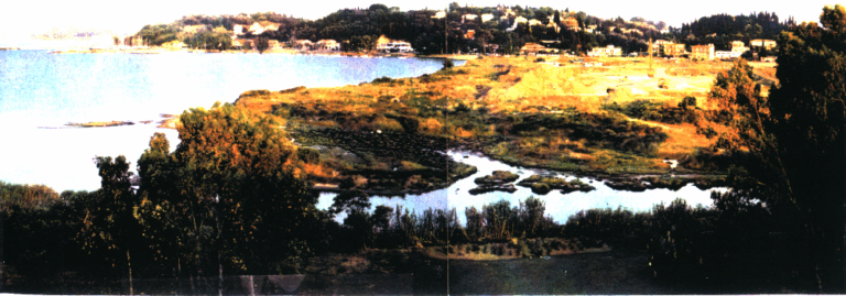
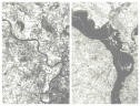
Rehabilitation management study of Potamos Kerkyras focused on riverbed restoration, pollution reduction, flooding prevention, and visual/ecosystem enhancement using phased interventions and alternative financing.
Developed a management plan for the Bouka wetland near Potamos River in Kerkyra, including artificial wetland design, area rehabilitation, and protection measures for construction near the sewage treatment plant.
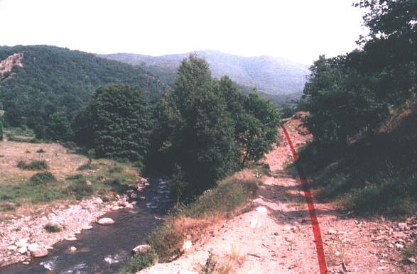
Improvement of the Kastoria–Florina national road, bypassing Kastoria and enhancing transport to Krystallopigi and Prespes. EIA included mitigation of noise, erosion, habitat loss near Aliakmonas River, and proposed measures for landscape and ecological protection.
Proposed to establish a large-scale biodiversity observation and simulation framework across EU sea basins. Included sensor networks, spatial prioritization for conservation, data integration from EO platforms, and modeling of biodiversity shifts due to human and climate pressures.
Proposed to establish a large-scale biodiversity observation and simulation framework across EU sea basins. Included sensor networks, spatial prioritization for conservation, data integration from EO platforms, and modeling of biodiversity shifts due to human and climate pressures.
Conducted hazard analysis and emergency planning for Valletta’s cruise terminal. Delivered evacuation protocols, risk scenario modelling, and tabletop exercises for Transport Malta.
The purpose of the project is to evaluate the risk from known threats and hazards that have the potential to significantly impact Malta’s security.
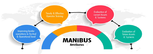
Proposed to design a 4D digital twin system for land and maritime border surveillance. Delivered interoperable platforms, training tools, XR interfaces, decision-support modules, and real-time integration of heterogeneous data for improved EU external security.

Implemented integrated coastal ecosystem management on Salamina Island through water quality monitoring, pollution modelling, and satellite analysis. Pilots addressed waste management, coastal restoration, and marine habitat protection under MEDSPA funding.

Developed a neurocomputing-powered framework to enhance climate modelling and adaptation strategies. Delivered co-creation tools, digital dialogues, and AI modules to support the EU Adaptation Strategy and climate literacy.
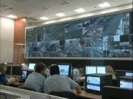
This multi-million project was initiated in 2003 and aimed at the covering of the security of the entire sector of the Olympics Games ATHENS2004. It involved real time security monitoring and actions for athletes, population, VIPS, city security, administration security, visitor’s security, international organizations security and numerous other sectors

Smart city digital twin ecosystem for disaster resilience. Integrated Copernicus, UAVs, and AI for early warning, real-time risk monitoring, and emergency simulation with cross-border collaboration features.

Environmental Impact Assessment for the Platamon section of the Athens–Thessaloniki High-Speed Railway. Evaluated air quality, noise, landscape aesthetics, and cultural heritage, with mitigation measures including noise barriers and slope planting.

Preliminary Environmental Impact Assessment for a 15km pipeline supplying water from Polyphytos reservoir to Kardia and St. Dimitrios power stations. Studied physical and biological environment, ensuring system reliability ahead of Athens 2004 Olympic needs.
Environmental Impact Assessment for the Preveza Perimetric Road and junction with the undersea Igoumenitsa–Aktio link. Aimed to divert heavy traffic from city center while mitigating construction noise, runoff, and vegetation loss.
Delivered Greece’s revised National Waste Management Plan (NWMP) aligned with EU Directive 2008/98/EC. Included 18 sectoral waste plans, geospatial mapping, cost-benefit analysis, financing strategies, and a regulatory framework supporting circular economy goals.
The project involved the Environmental Impact Assessment for a 97ha industrial zone near Rhodes city, targeting the relocation of industries, mitigation of pollution, and economic development of the prefecture.
The project developed an integrated environmental management plan for Salamina, focusing on coastal protection, pollution modeling, satellite imagery analysis, and pilot actions in waste and nature conservation.
SCIER is implementing a multi-risk management platform, characterized by an open architecture based on EU standards, which incorporates different models that share common data inputs and deliver standardized outputs that can be visualized and analysed via a GIS user-friendly environment.

Proposed to develop an open-access web platform for maritime safety, modeled after SKYbrary (aviation). Included human performance modeling, risk-based operational design, incident databases, training optimization tools, and modular safety innovation toolkits.
Environmental Impact Assessment for the V Irrigation Project of Serres, spanning 4,500 ha with intakes from Strymonas and Aggitis rivers. Addressed changes to river flow, agricultural runoff, noise, and habitat disturbance, proposing minimum flow and pollution mitigation.
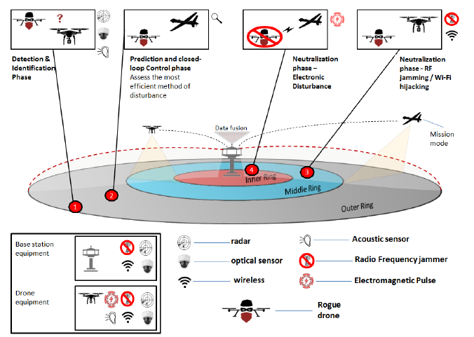
Proposed to deploy a multi-tier cybersecurity and threat-detection platform for protecting water infrastructure using IoT, UAV/USV surveillance, and AI analytics. Covered early-warning, anomaly detection, physical intrusion prevention, and cyberattack countermeasures.
Proposed to deploy a multi-tier cybersecurity and threat-detection platform for protecting water infrastructure using IoT, UAV/USV surveillance, and AI analytics. Covered early-warning, anomaly detection, physical intrusion prevention, and cyberattack countermeasures.
Services for tourism, transport, environment, health, civil protection, under a 3D Tablet-PC interface, for 20+ Mediterranean Islands, Greece, Italy, Spain, Cyprus, Malta.
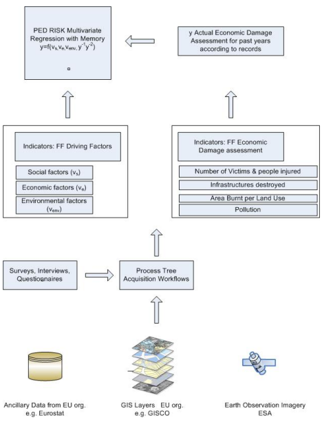
Created a socio-economic toolbox and mathematical model to evaluate forest fire prevention vs. recovery. Developed EU-wide guidelines, risk indicators, and facilitated global knowledge exchange on forest fire resilience.
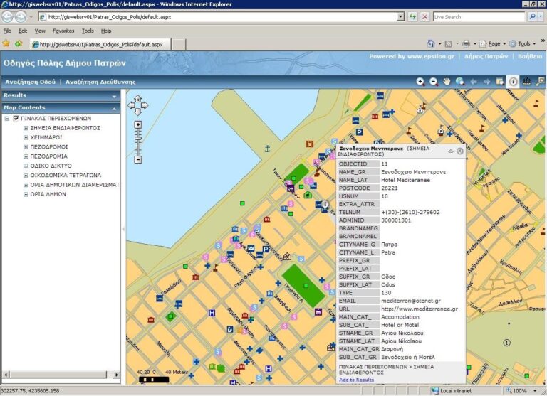
Developed and deployed the Spatial Data Infrastructure (SDI) for the Patras region, aligning with INSPIRE and OGC standards. Delivered GIS tools, public web services (WMS/WFS), stakeholder training, awareness booths, and long-term capacity building for urban planning and land administration.
Delivered accredited GIS and geomatics training to public servants in Malta. Developed L4 and L5 programmes, hands-on courses, and technology-enhanced learning tools aligned with national workforce needs.
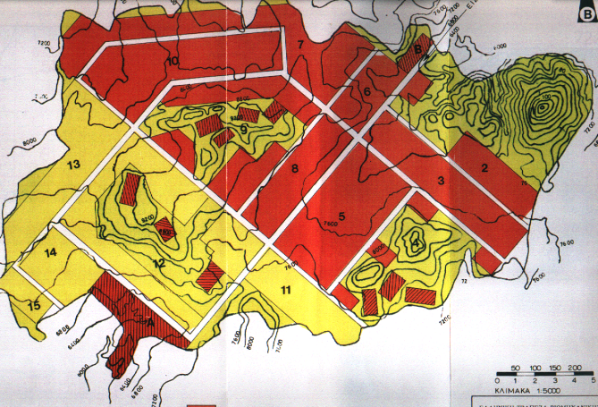
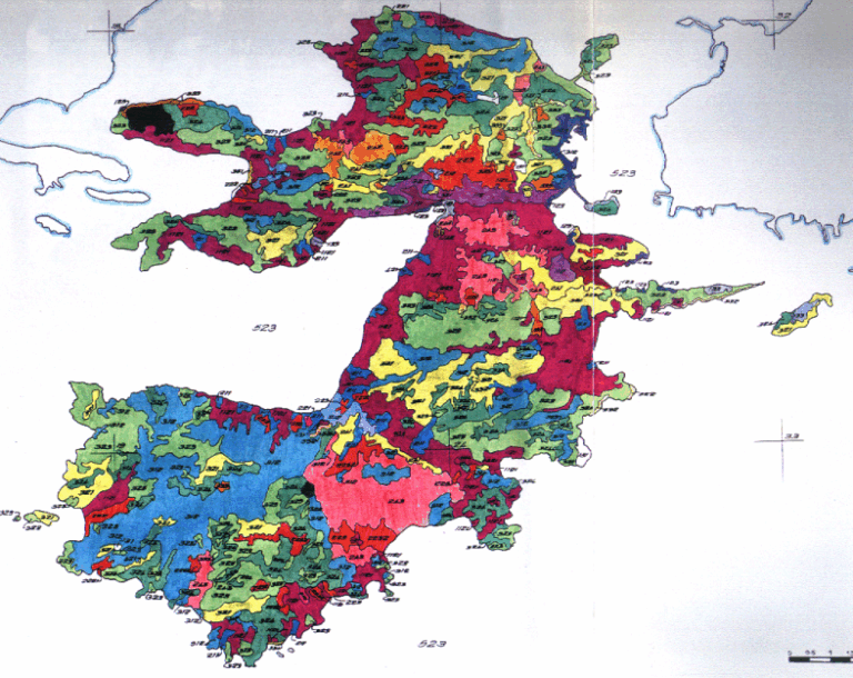
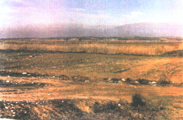
The overall objective of the project was the design and development of a Geographic Information System for the prevention and monitoring of natural disasters that derived from forest fires at the university forest Taxiarchis – Vrastamon as well as a zone of one kilometre around the forest.
The objectives of this project are to improve the assessment and management of urban risks in the 25 members of the European Union and to arrive at recommendations for a European wide urban risk assessment, and management strategies to ensure better prevention, preparedness and response in the context of an integrated Civil Protection System.
Remote sensing (ESA/Copernicus) technology delivering sustainable solutions to overcome broomrape plant parasitism in Mediterranean agricultural systems.